

| | | | | | |


| Last Update: October 30, 2006 |
| Special Thanks to Jeff Moore for some of the information contained here. Check out his website regarding this branch, and to Sam Davey for the historical early 1990s photos. |
| The Union Pacific Heppner branch began life in 1889 under the Oregon Railroad & Navigation Co. which was owned by the Union Pacific by that time. The line was would originally be called the Willow Creek Branch, since it generally followed Willow Creek much of its route. The line began at what was once called Willow’s Junction at the Union Pacific mainline along the Columbia River, approximately 10 miles east of Arlington, Oregon. Although, always under the ownership of the Union Pacific, the company operating the line would change names several times over the years, and would later be known as the Oregon-Washington Railroad & Navigation Company. By the 1950s, the lines operated by the O-WR&N, including the Heppner Branch, were generally simply known as divisions or branch lines of the Union Pacific. The Heppner Branch was built to mainly serve agriculture interests along the 45 mile long route between the Willows Junction and the town of Heppner. Over the years, saw mills were built and served along the route as well. Several towns along the route also had depots for passenger service. Although its not clear how often passenger service was in use, it most likely ceased around the 1930s during the period that automobiles became much more prevalent. In 1953, the Kinzua Pine Mills Corporation built a saw mill in Heppner and for the next 50 years, this proved to be one of the major shippers on the line. It would also be the last shipper. In the last years of operation, twice a week, on Tuesdays and Thursdays, the Union Pacific would run a train from The Dalles, 59 miles east on the main line until Heppner Junction, where it would run the 45 miles down the Heppner branch to the Heppner. The primary shipper in the final years was the Kinzua Mill in Heppner. While numerous grain silos existed on the line along the entire route, its unclear if these were shipping by rail in the later years. If they were, it would likely only have been seasonal Union Pacific was unwilling to invest in the decaying branch line as the relatively light traffic didn’t justify the cost. They applied for abandonment in approximately 1993 and despite protest from the Kinzua Pine Mills and City of Heppner was granted permission to abandon the line by 1994. The last train ran on the line on June 30th, 1994 to pick up an empty bulkhead car from the Kinzua Mill. Shortly thereafter, the rails were picked up. Little trace of the line was left behind. The wood trestles were completely torn out, as were the steel bridges. Only the concrete piers hint at what used to exist. Most of the ties were given away to locals or destroyed, although an occasional pile can still be seen next to the abandoned right of way. Most of the abandoned right of way is nothing more than an overgrown mound of dirt, but some sections were converted to roads by local farmers and ranchers. In Heppner, a short section of track remains behind in the middle of town, where a small historical display of farm equipment and one wooden boxcar hint at the railroad that was once there. Not a single depot remains in any of the towns, however, one depot was partly saved and moved, only to fall into disrepair and be essentially abandoned again. See below for more info. |


| An old version of Union Pacific's Logo incorporating the Oregon-Washington Railway & Navigation company name. |
| Map of the Heppner Branch. |

| Its a little difficult to tell in this picture, but this is the beginning of the Heppner branch as it leaves the Union Pacific mainline. This section of track still exists today and is used for car storage. Approximately a mile or so of track remains. On the left is the UP mainline that runs along the south bank of the Columbia River. On the right are the twin bridges that were built for the Heppner branch to cross over Highway 84. This was originally called Willows Junction, before it was later changed to Heppner Junction. The double track section of the UP mainline located here is still known as Willows. Photos: July, 2005 |

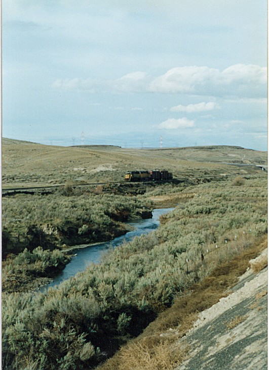
| This photo shows the line at approximately milepost 3 and 4, well after the beginning of the abandonment. Much of this section has been reclaimed by local farmers and the old grade is used as a dirt access road. Photos: July, 2005 |


| The little town of Cecil is located at approximately milepost 14 on the line. Here a major grain elevator still exists that the line served at one time. Across from the grain elevator is this tiny general store that is still in business. Note the old railroad milepost numbered 14 that was probably moved when the line was abandoned and torn out. Photos: July, 2005 |


| South of Cecil is this deep cut built for the railroad in the late 1880s. Today the grade has been turned into a little used access road in this area. Photos: July, 2005 |


| Probably the most interesting remains of the Heppner branch is this depot, which is surrounded in mystery. My wife gets credit for spotting it. Because it wasn't located next to the railroad, I missed it. It's actually located east of Highway 74, while the railroad tracks are located west of the highway. Its also not located near any townsite, so it was clearly moved here at some point. The town of Ione is located 8 miles to the south and had a depot that looked exactly like this one, so I suspect that's where it's from. The depot in Ione existed there well into the 1960s, but when it was moved here is not clear. As you can see, the depot is in terrible shape and almost appears to be abandoned at this site. No other depots exist along the entire old railroad grade that I could find. They were most likely all torn down by the time the railroad was abandoned or shortly thereafter. Photos: July, 2005 |


| Unfortunately the sun didn't cooperate, but this is one of the major bridge sites along the line. The branch line didn't have any extreme large bridge or trestle work, but the multiple concrete piers indicate that at least several steel plate girder bridges were probably placed here to allow the line to cross Willow Creek. The concrete workings here hint that several different types of bridges were used at this site over the years. This site is located near the local of Morgan at approximately Milepost 20 along the route. Photos: July, 2005 |


| At approximately 1 mile south of the above bridge, the line again crossed Willows Creek via this bridge. Once again, the bridge is totally gone, but the concrete piers remain. I suspect this was single steel plate girder span with wood trestle work at either end. Photos: July, 2005 |


| These photos were taken at approximately Milepost 22 and show the heavily built up workings of the grade as the line heads south out of Horseshoe Bend. Today, the grade is used as a local access road in some sections in this area and in other sections, completely abandoned all together. Photos: July, 2005 |


| Another major built up section of the line at approximately Milepost 23. Probably built up to avoid flooding from Willows Creek. In the early 20th century, much of the valley was nearly wiped out by major floods, although the damage didn't necessarily reach this far down creek. Just beyond the rise, a low level trestle existed, but no remains exist today. Completely torn out by the Union Pacific, probably much to the joy of the local farmer who plows the field that the bridge used to cross. Photos: July, 2005 |


| The grain silos at McNab, at approximately Milepost 25 and photos of part of the grade now turned into an access road. These were once served by the railroad, but no more. Photos: July, 2005 |

| The grain silos at Jordan at approximately milepost 31 Photos: July, 2005 |


| At approximately milepost 33/34 the line once again crossed Willows Creek via this bridge. Only the concrete pier remains today. Photos: July, 2005 |


| At approximately milepost 36/37 the line entered the town of Lexington, where it once served this major grain silo complex. Photos: July, 2005 |

| This painted crossing warning at the east end of Lexington is one of the few remaining hints that a railroad once passed right through the middle of this town. Photos: July, 2005 |


| One of the few remaining sections of rail is located here at approximately milepost 42. This a private crossing that leads to a farm house. Scrappers apparently chose to just leave the rails in the asphalt rather than try to dig them out. Photos: July, 2005 |


| This building is locate right in the middle of Heppner where the line used to end. A depot and small yard used to be located here. I suspect this building was related to the railroad in some way. Possibly as a freight depot at one time. Photos: July, 2005 |


| The actual end of track in Heppner just east of where the depot used to be located actually still has the track in place. Left behind to allow the city to use it for display purposes. Today a small farm equipment display and an old wood box car occupy the track and surrounding area. This would have approximately milepost 45. The end of the line. Photos: July, 2005 |
| Historical Photos |


| These photos are part of Jeff Asay's collection who was kind enough to allow me to share them. Note the two different types of depots used at Heppner between 1963 and 1978. These photos make it quite evident how much has changed since the railroad was abandoned. The photo of the Ione depot from 1963 seems to confirm that its one and same of the depot that I photographed several miles out of town sitting apparently abandoned along side the highway, after it was apparently moved. Photos: 1963/1978 Courtesy of Jeff Asay |
| If anyone has any further information or pictures about the Heppner branch of the Union Pacific, especially pictures, please let me know. You can Email me anytime. Thanks. |
| Copyright © 2005, 2006 Brian McCamish, All Rights Reserved Note about the photos on this site: Most photos were taken by me, except for those that are otherwise indicated. I usually allow people to use my photos for personal use or websites. Simply Email me. I may not have authority to grant permission regarding some photos that were only loaned to me by others specifically for this website. Every effort has been made not to include other's photos without the proper permission and credits, however, if you see any photos which belong to you and that I don't have permission to use, I apologize. If you send me an Email, I will remove the photos immediately or give proper credit, which ever you wish. Thank you. |
| Return to the Railroad History Page Return to the Historical Expeditions Page Return to my main Home Page |


| These photos were taken of the Heppner Branch in it's final years of operation in approximately 1993. Photos: 1993 Courtesy of Sam Davey |