


| Last Update: January 11, 2006 |

| General Map of the Railroads discussed here Blue dots indicate the 1935 abandoned sections of the Deschutes Railroad. Red dots indicate the Oregon Trunk Line that today is operated by the BNSF and the UP jointly, and continues to Bend, Oregon and beyond. Green dots indicate where the Oregon Trunk and Deschutes shared track beginning 1921. |
| Part Two of a two part series Click here to return to part one This part contains: The Abandoned Oregon Trunk from South Junction to Metolius The Active line from Madras to Bend Historic Photos of the Oregon Trunk/Deschutes Railroad |
| The abandoned Oregon Trunk. |
| South Junction, located 10 miles south of North Junction is where the two lines once again seperated and went their own ways. The interesting part is that of the two lines, one was abandoned and the other retained, but instead of abandoning the Deschutes Railroad as was done north of here, it was the Oregon Trunk section that was abandoned in this area. From South Junction, the Deschutes Railroad winds it's way southeast away from the Deschutes Railroad before cutting south and eventually reaching Madras on an inland route. This is the section that still survives as an active railroad today. The Oregon Trunk, on the other hand, chose to continue to follow the Deschutes River, but this time on the east bank and roughly followed the river south for another 20 miles, before turning east into Willow Canyon and following that into the Madras. This section was abandoned in 1923, only a little more than 10 years after it was built. The two railroads were already sharing the line between North and South Junctions, so it only seemed logical to consolidate further south of there. Especially, considering that the Oregon Trunk section had numerous maintainence problems with rock slides, old wood trestles that needed rebuilding and steeper grade. Trackage rights were granted to the Oregon Trunk to operate over the Deschutes railroad from South Junction through Madras all the way to Metolius. Much of this abandoned section was turned into roads, including a dirt road along the Deschutes River that is now closed to the public, and major highway through the area was built on a short section of grade. One extremely interesting tunnel along this route still survives and is very easily accessable, but just hidden enough that most people dont' even know it's there. Two more tunnels used to exist in Willow Canyon, but were demolished during World War Two for training purposes. |


| This neat tunnel was supposedly built around 1910-1911. Although the date on the tunnel indicates 1912, the line was suppose to have been opened before that point, which leads me to question if it was actually concrete lined after it was already open to trains or if the history books have it wrong and the line actually wasn't open until after 1912. Note the remains of the doors and electrical components, and air ducting that were almost certainly added after the tunnel was abandoned as a railroad tunnel and then converted into a Potato Storage facility sometime after 1924. This is the north portal. Photos: 2002 |


| Although serving as a potato storage facility for a while, the tunnel is now most definitely abandoned. Access is right off of Hwy 26, just east of the Deschute River bridge. One can drive right to the north portal and walk through it. This is the south portal which appears to have experienced a major landslide many years ago. Photos: 2002 |


| These two photos were taken in December and show the north portal with snow covering the area. The other photo shows the railroad grade leading north away from the portal. Note how the grade went over a large fill a few hundred yards north of the tunnel portal. Today, this section of grade is a single lane dirt road, but a second gate not far north of here, limits access. Photos: December, 2005 |
| Willow Canyon - Two abandoned daylighted tunnels |
| Willow Canyon was where the old Oregon Trunk Railroad left the Deschutes River and began to head east towards Madras. Today, the railroad grade is still quite prominent in Willow Canyon, well over 80 years after it was abandoned, because it was later turned into a little used dirt road. The old Oregon Trunk grade then crossed a bridge from one side of Willow Canyon to the other, before crossing under the Deschutes River steel railroad and entering Madras. Two tunnels were dug into the rock for the Oregon Trunk on this section, but neither survive today. They were blasted during World War Two for demolition practice by the Army. However, the cuts caused by the blast do remain and people can hike through the grade where the tunnels once were. |

| Map of Willow Canyon and the two abandoned tunnels. |


| I took these photos of the bridge and old grade from up above in 2004. In these photos you can see the old footbridge, which you'll see again up close below. |


| This bridge, just west of Madras over Willow Canyon, is where the old Oregon Trunk and the Deschutes River bridge meet again. The impressive steel bridge was constructed by the Deschutes Railroad in approximately 1910. It's well over 200 feet tall. 95 years later it still carries trains over it on a daily basis. The original Oregon Trunk passed under the bridge as it exited the east end of Willow Canyon. August, 2005 |


| The first photo shows the beginning of the trail that leads to the railroad grade at the east end of Willow Canyon. Walking along the grade on south side of the canyon, its clear that that the grade was turned into an access road. Most likely for an abandoned pumping station that we found just down the road. This foot bridge was erected to span the canyon in the same approximately location that a railroad bridge used to exist until the line was abandoned in 1923. August, 2005 |


| Just after crossing the footbridge we were on the north side of the canyon and were again walking on the old railroad grade. Just ahead was the first tunnel site. Today, the tunnel site is daylighted. This and it's sister tunnel just a quarter mile or so beyond were apparently both blown up during World War Two. August, 2005 |


| This is the second abandoned tunnel that was blown up. Both tunnels were used for demolition training by the U.S. Army during World War Two. Presumably, the tunnels were still intact by the 1940s, until they were blown up. August, 2005 |
| Madras |
| Madras was a major city along the Deschutes Railroad route. While the Oregon Trunk, skirted Madras and headed south for Metolius only several miles away, the Deschutes River major an area just north of the town proper of Madras, a major stop. In more recent years, an industrial spur was constructed northwest that houses approximately 2 miles of track broken up into 3 different spurs. Today, the depots are long closed, but it is still a major maintenance station for the modern railroad crews that are based out of here. Spare parts, maintenance trucks and a little office building exist here. A mysterious depot like structure also exists here. While quite likely railroad related, its exact function is not clear. Perhaps a freight depot, perhaps a house for section foreman. |

| Map of Madras Station which is actually located just north of Madras the City. |


| The first three photos are looking north from the south end of Madras Station. The old freight platform has long since been abandoned. As has the old building next to it, which appears to be an ex-freight depot, or perhaps a section foreman's house. August, 2005 |


| Note the brand new welded rail ready to put be put into place if needed, dated 2002. One very interesting aspect of this rail is that it appears to be designed to step up or down from a lighter weight rail to a heavier weight rail. Perhaps intended to connect an older spur or siding to the mainline. Also note the brand new freight car wheels, complete with brand new bearings. I assume these are stored in the event a bearing burns out on one of the trains. Then one of these wheels can simply be dropped in it's place and the train on it's way. August, 2005 |


| Located near where the old depot used to be is this little trailer/office structure. It appears to be used by local railroad maintenance crews. Note their trucks parked outside. Interestingly, even though the line is shared by both the UP and BNSF, it seems to be primarily BNSF crews that maintain it. August, 2005 |
| Metolius |
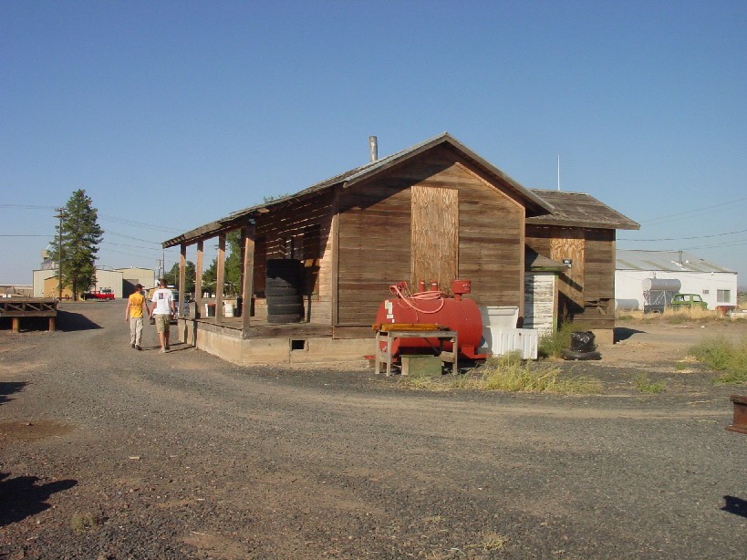
| This depot at Metolius, was built in 1911, by the Oregon Trunk Railroad. Metolius was a significant point, because this is as far south as the two companies build separate lines. Even in the earliest days, the Oregon Trunk and Deschutes Railroad would share the single railroad from here, south to Bend. Burlington Northern quit using this depot as a train order station in 1978 and planned to cut it up and scrap it. City leaders saved the building from demolition when they bought the depot for just $1 dollar in 1983. Sitting on the west side of the tracks about 100 feet south of its current location, the building had to be moved south, to city property. However, little has been done to the building in the last 20 years. Much of the equipment, paperwork and supplies that existed from BN when the building closed in 1978, still lay inside where they were left. However recent plans from mid 2004 include major repairs of the roof and eventual conversion of the depot into a local museum as outlined in this April 18th, 2004 article from a local newspaper. |

| Map of the area. |


| Photos of the Madras Depot that I took, when I first visited it in 2004. Note the old steel tank that I spotted left behind. It appears to be a old fuel bunker tank, possibly from a steam engine, but not sure. Summer, 2004 |


| This semiphore was located next the depot when it was in use. But just as the depot was moved in the late 1970s, so was this semiphore. August, 2005 |


| Culver |
| Culver is a small town built next to the railroad. Ironicly, the railroad doesn't serve Culver much these days, and now the main highway through the area has bypassed it, limiting Culver's modern day growth. |


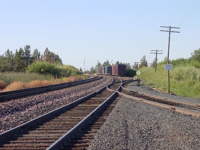
| This northbound freight has just rounded Juniper Butte and is about to pass through Culver. August, 2005 |
| The Crooked River bridge |
| The Crooked River bridge may not be the longest or the largest of the bridges along this route, but it most certainly is the highest. In fact at approximately 300 feet high, it's one of the highest railroad bridges in the world. Built in 1910 along one of the most contested spots along the route. The Oregon Trunk reached this spot first and got the best place to erect the bridge. This is the narrowest point in the canyon and therefore was the best place to build the bridge. Today, heavy diesel power freights use this very same bridge built almost 100 years earlier. |


| I've desperately tried to catch a photo of a train going over the bridge. Though unsuccessful, the first two photos show how close I was. Travel at over 60 mph, this northbound freight is just about to cross the Crooked River bridge. The bridge is almost entirely original. Although well maintained, the arid dry weather of Eastern Oregon helps too. I sometimes wonder if the original designers could have imagined the incredible weight of trains that now pass over this bridge today. August, 2005 |
| Terrebonne |
| Terrebonne is a small town along the route, that was lucky enough to also reside next to the main highway. While the railroad only passes through Terrebonne today, a freight depot, and a passenger depot exist here. Both still exist, although in slightly modified state. The freight depot in the background of the middle photo was built in 1919. The passenger depot is the current building shown in the middle and right photos. It was built in 1911 and only had one story. In the 1930s, the building was moved from it's original location and a second story added. |


| Located at milepost 129, means that Terrebonne is 129 miles south of the Columbia River by railroad. Today this is the site of a passing siding. The freight depot in the background was built in 1919. The passenger depot in the foreground was built in 1911. August, 2005 |


| These photos taken in December, 2005 show progress on the restoration of the building. See below for more info. December, 2005. |


| These two photos of the passenger depot are courtesy of the current Terrebonne depot owner, Kristin Yurdin. The photo on the left is from the Deschutes County Historical society and shows the original depot before it was modified. The photo on the right is a modern photo in it's unrestored state. Note how the depot originally had one story, but now has two. The second story was added in the 1930s. Current plans are to turn the depot into a restaurant. We wish them best of luck and will be sure to post photos when the renovation is completed. |


| Not much is know about the freight depot. It was built in 1919 and appears to be built on elevated studs. The extremely heavy duty platforms on either end have survived somewhat intact. It probably hasn't been used by the railroad in many decades, but appears to be used as storage for a local. December, 2005 |
| Prineville Junction. |
| Prineville Junction is where the City of Prineville Railroad meets up with the Oregon Trunk Railroad. The City of Prineville Railroad was built in 1916 by the residents of Prineville, when it began clear that the Oregon Trunk was not interested in building a spur, some 19 miles to the town. Over the years, until just recently, the railroad had been immensely successful. However, with the closer of several mills, the line's traffic has been substantially cut back. Today, a dinner train and some freight makes up most of it's use. But a concerted effort is underway to reinvigorate the line. To learn more and see many more pictures and video of this line, check out my City of Prineville Railway Page. |


| This is Prineville Junction today. It consists of several sidings, and a wye for the City of Prineville Railroad. August, 2005 |
| Redmond |
| Redmond was another major stop on the line with a very fancy rock depot, and number of freight depots. Today, the rock depot has been moved, and the remaining freight depots either torn down or sold off to be used for other purposes. However, Redmond is still a major stop on the line's current freight operations. A switcher is sometimes based out of here and a small yard handles a little bit of local traffic. |


| Photos from around the Redmond yards. A moderate amount of traffic is switched out here. A Union Pacific switcher is sometimes stationed here. A wye and spur heads into a mill site, but I'm not sure if its currently in use. December, 2005 |


| The Redmond depot is extremely unique in that it was built out of cut rock. The date of construction is not known, but it was abandoned for several years, before being moved, piece by piece to the south end of Redmond only a few years ago. It's still located near, but not on the railroad tracks and today is used as a restaurant. December, 2005 |
| Deschutes and Bend |
| Unfortunately, I have not had a chance to photograph the last few miles of the line which passes throughDeschutes and ends in Bend, the largest city in Eastern Oregon. Look for an update when I'm able to finally photograph what's there. |
| HISTORIC PHOTOS |
| These Black and White photos are courtesy of the Salem Public Library Historic Photographs Collection, (Ben Maxwell Collection) and are used here by specific permission. |


| Nathan (Hardy) 1938. The road across the river is the old Deschute Railroad that was abandoned just a few years earlier. |
| South Junction, 1965 |
| Deschutes River, below Maupin, 1915. The Deschutes RR can be seen on the right. |


| This photo of Maupin from 1960, shows the SP&S line (today BNSF) on opposite side of the Deschutes River. The old Deschutes Railroad was on this side and the abandoned grade can almost be seen in this photo. |
| This 1915 photo shows a large trestle on the Oregon Trunk near Warm Springs Ferry. I believe that location is know as Sinamox on current maps. This trestle was likely replaced with steel viaduct that is still used today. |
| Sherars Falls, in 1965. The Oregon Trunk, now BNSF is seen on the opposite side of the river. The photo is taken from the abandoned Deschutes RR, which was turned into a road in this area after it was abandoned. |
| This photo of the SP&S bridge near Sherars Br. taken 1965. This near the location of where the two companies constructed their tunnels right next to each other. In fact the bridge heads directly into a tunnel to the left. This picture was most likely taken from or near the abandoned Deschutes River RR tunnel north portal |
| These Black and White and photos are courtesy of Steve Addington. They were origonially taken by his father, Murl Addington. Murl was a section foreman for the Oregon Trunk from the 1950s through the 1970s. |

| Photo of the section crew with Murl Addington sitting on the push cart. Photos by Murl Addington, courtesy of Steve Addington. |

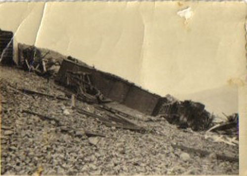


| These are photos of a head on accident between a diesel and a steam engines that occured above Sherar's Bridge on the Oregon Trunk. The year was most likely in the 1950s at the end of the age of steam. Photos by Murl Addington, courtesy of Steve Addington. |


| These photos were taken of an extra Gang's outfit cars that apparently burned while the crew was working, somewhere on the Oregon Trunk. In the photo on the far right a Malot type steam is coming around the corner, dating the photos to the around the late 1940s or early 1950s. Photos by Murl Addington, courtesy of Steve Addington. |


| These are photos of a major washout that occured on the upper side of Gateway hill on May 7, 1957. Photos by Murl Addington, courtesy of Steve Addington. |

| Comments about this photo from Steve Addington: This mororcar belonged to Ted Lewis who was the track inspector at the time. He parked it on the passing track at S.J. about halfway between the crossing and the depot but forgot to set the brake. The UP cane down and sort of sucked it along with it until it got to the switch in front of the depot. The houses in the background were where the opperaters lived. Doc Moyer lived in the one directly behind the motorcar. Photos by Murl Addington, courtesy of Steve Addington. |
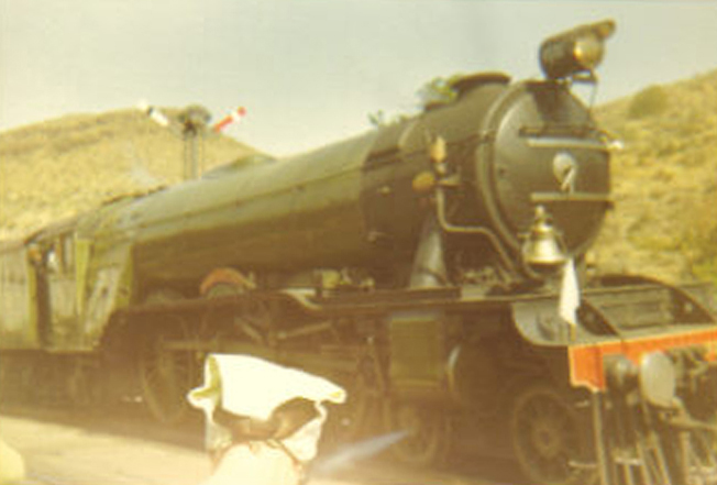
| The Flying Scottmans in front of the Maupin depot in 1971 or 1972. Photos by Murl Addington, courtesy of Steve Addington. |
| Click on the below links for addition information about this railroad and it's colorful history. http://www.gesswhoto.com/sheriff-sherman2.html http://www.paddlewise.com/stories/george.html A link with a few photos of the Deshutes area today |
| If anyone has any further information or pictures about the Oregon Trunk Railroad and/or the Deschutes Railroad, please let me know. You can Email me anytime. Thanks. |
| Return to the Railroad History Page Return to the Historical Expeditions Page Return to my main Home Page |

| Copyright © 2004-2006 Brian McCamish, All Rights Reserved Note about the photos on this site: Most photos were taken by me, except for those that are otherwise indicated. I usually allow people to use my photos for personal use or websites. Simply Email me. I may not have authority to grant permission regarding some photos that were only loaned to me by others specifically for this website. Every effort has been made not to include other's photos without the proper permission and credits, however, if you see any photos which belong to you and that I don't have permission to use, I apologize. If you send me an Email, I will remove the photos immediately or give proper credit, which ever you wish. |
| Oregon Trunk Crooked River bridge, taken around 1910 of the first train to cross this bridge, which is still used today by BNSF. |

| More photos of the depot and surrounding track. The depot was back from the track about 100 feet from its original location to get it off of railroad property and onto city property who now owns the buildings. Although its current being worked on, the depot is in fairly original condition from the last days it was used by the railroad. August, 2005 |
| | | | | | |
